The Perfect Postcard
Vancouver has gone through considerable and at times very dramatic changes over the past 25 years. Ask any of the old timers and they will peg Expo 86 as the seminal moment in our history that moved Vancouver onto the world stage and let slip the winds of change.
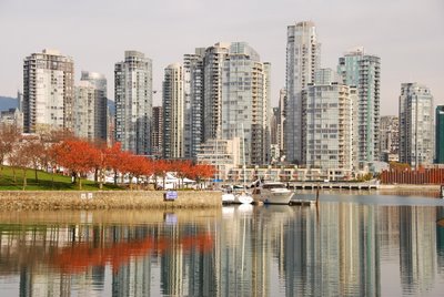
Perhaps the most dramatic change has been to the architectural look and feel of the city itself. Slowly Vancouver has morphed a unique skyline that it can claim as its own. What was once frumpy and pretentious pre-post-modern '60s shtick has, thankfully, been updated into one of the most stunning profiles in Canadiana.
I arrived in Vancouver 5 years after the close of Expo and already the downtown skyline had begun a radical transformation. The change has been most dramatic in what was once the grounds of Expo itself. For most of the decade following Expo the area on the north east corner of False Creek (an inlet in the south east corner of the city) was nothing more than a huge empty lot. 20 years after Expo however this region has been almost completely transformed and now includes one of the coolest mixes of 21st century urban architecture on the planet. Cool enough in fact that Vancouver and what has become known as Yaletown often acts as a stand-in for movie studios looking for a backdrop that gives a nice near-future look to their films.
Given the architectural splendor all around me I'm needless to say searching for the perfect postcard shot of my home town. And, being a bit of slacker, I've decided to replicate what worked in the past before I branch out and do something new.
After all, 'derivative' takes less work right?
Well, not always. As it's turning out even though I have the image I want to replicate finding the angle where it was shot from has turned out to be bit of a struggle.
Here's the image that, as close as I can guess, was taken a few years following Expo-86. My hunch is that it was taken during the spring of 1988 or 1989. My goal then is to find this location and replicate the shot as it is today.
I had this image in my mind's eye four weeks back when I drove over to the middle south part of False Creek. My goal then was to find the matching angle and get the image needed to do one of those funky That Was Then This Is Now comparisons for this blog.
However, after a few hours of roaming the west and mid south shore of False Creek and finding some great and non-derivative angles of downtown Vancouver I had gathered loads of postcard material but not the exact image I had charged myself with finding.
My quest has just begun then and once the weather gets back to it's "regular programming (read civilized) I'm taking a hard copy of this picture and heading out to what I'm pretty sure is the spot it was taken from. The south east corner of False Creek is my guess.
Stay tuned. My guess is the Before and After images are going to be just this side of Night and Day.


